
Understanding how Future climate data were generated
Climate is the average weather patterns at a given point and time of year over a long period (typically 30 years). We expect the weather to change a lot from day to day, but we expect the climate to remain relatively constant defined by a baseline climatology
If the climate does not remain constant, we call it climate change.
It’s crucial to understand difference between climate change and climate variability:
Climate variability – The way climate fluctuates yearly above or below a long-term average value.
Climate change – Long-term continuous change (increase or decrease) to average weather conditions or the range of weather
Climate change impact : Why downscaling is needed?
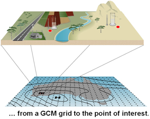
Global climate change impact assessment studies, such as the IPCC reports have led to renewed interest in local climate simulation, as the output of General Circulation Models (GCMs) cannot directly be used in any regional hydrologic or crop model of interest. GCMs are the most credible tools designed to simulate time series of climate variables globally, accounting for the effects of greenhouse gases in the atmosphere and can perform reasonably well in simulating climatic variables at larger spatial scale (>104km2), but poorly at the smaller space and time scales relevant to regional impact analyses.
There are more that 20 GCMs (embed link to CMIP5 website) from research centers around the world. It is important to undertake assessments of their outputs to determine which models best represent the climatology in the MENA region.
There are more than 20 GCMs (embed link to CMIP5 website) from research centers around the world. It is important to undertake assessments of their outputs to determine which models best represent the climatology in the MENA region. Once the most representative models selected is downscaling techniques to derive more local data may be used. These relate large-scale climate variables to regional- or local-scale meteorological/hydrological variables, and serve as tools to generate synthetic weather data required for climate change impact assessment studies. Two types of downscaling techniques exist: Statistical and dynamical downscaling.
Dynamical downscaling is the way of obtaining fine resolution climate data on limited or global area by driving a weather-forecasting model with data from coarser climate model. In most cases a regional model is used to provide multiple climate parameters needed to drive hydrologic/crop model for local climate change impact assessment.
Statistical downscaling is a two-step process consisting of i) the development of statistical relationships between local climate variables (e.g., surface air temperature and precipitation) and large-scale predictors (e.g. pressure fields), and ii) the application of such relationships to the output of GCM experiments to simulate local climate characteristics in the future.
To find out how to do this follow links to Dynamic downscaling or Statistical downscaling.